UPDATE: At 4:57 p.m., the NWS updated the flash flood warning to include southwestern Kane County, effective until 9 p.m. Flash flooding is expected through Buckskin Gulch, as well as across the Wave and House Rock Valley Road.
KANE COUNTY — The National Weather Service in Salt Lake City has issued a flash flood warning for central Kane County effective until 11 p.m. Sunday.
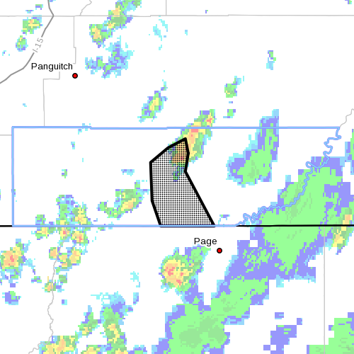
At 3:54, Doppler Radar indicated thunderstorm producing heavy rainfall over the headwaters at Wahweap Creek, as well as tributaries of the Paria River. A swath of rainfall in excess of 1 inch has already fallen, with additional storms moving into the area into early evening.
A flood wave is expected to move down Wahweap Creek through the evening hours, reaching Big Water by late evening. An additional flood wave is expected to move down the Paria River over the course of the evening.
Precautionary/preparedness actions
Move to higher ground now. Act quickly to protect your life. Remain alert for flooding even in locations not receiving rain. Dry washes, streams and rivers can become raging killer currents in a matter of minutes, even from distant rainfall.
Related posts
- I can’t believe I survived; video of flash flood crashing down on canyoneers
- ADOT begins repairs along US 89A following House Rock Flood
- UPDATE: Flood closure area partially reopens on Highway 89-A
Email: [email protected]
Twitter: @STGnews
Copyright St. George News, SaintGeorgeUtah.com LLC, 2015, all rights reserved.